Urban planning: local development plan defects- part 2 is the second article of a series of articles. This article will discuss the remaining three areas of concentration of local development plan defects in the plan-making process: City structure, Environment, Mobility.
Following my previous discussion about the UK local development plans, concerning the city structure study, the plan studies the city structure not in terms of the city’s physical components (you can read my articles on the urban design using the city in layers concept). The study divides the city into areas the Inner city, outer city, town centers, sub-regions (green belt ), and intensification and opportunity areas. We can observe the repeat of studying the areas economy (unemployment), environment, demographic growth, neighborhoods and public realm, and deprivation. A real personal observation of one of London’s council on the time and efforts allocated to prepare this plan from the planning manager shows that the team spends one year and still there are lots of infill information and repeated text at the same time the waste of time and money to prepare the plan. for example, the London plan 1983 outer-city study is similar in content and information to the London plan 2016. The study indicates in its policy outer-London will continue to support the inner-London essential needs for housing, and to protect and promote the high-quality environment and ongoing development. 35 years of a similar approach, technique, and style to study the city without any development. For town centers in both these plans, the policy directs for the needs and necessary access of people to amenities and retail service as well as public transport.
In analyzing the city structure study areas we find always common concerns in all the previous and present local development plans. These concerns are the decline of business, shift of business, and creating new business. Why it’s always about business? Why it’s always about employment?
Yes, population growth and the employment and unemployment rates. Another repeat of study and lots of infill of information and repeated text. Many people who do not have sufficient knowledge about planning will not recognize when the local development plan is uploaded for public consultation the hidden concern about unemployment and business decline. There are several goals for economic development in certain communities, towns, and cities. These include job creation, job retention, tax-base creation, increase in property value, and economic stability.
Job creation by occupation and industry readily available in the community is more effective and productive than recruiting businesses from outside the community (In the end it’s about the tax paid to authorities). Similarly, one job retained will benefit the community as much as one job created. Economic development specialists look for real estate development prospects such as suburban office buildings and hotel projects because most communities rely on real property taxation and that is tax base creation. Rapid economic growth may increase property value in the short run, but maintaining a high quality of living is the best guarantor of a long-term increase in property value. Businesses should target services and products produced to a variety of markets to maintain community economic stability. These goals of economic development’s main objective are to generate TAX for authorities. Yes, there is always a struggle to obtain FUNDS for the authority development project.
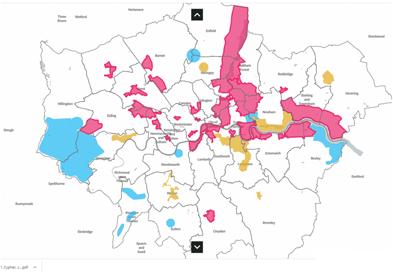
Intensification and defining development opportunities (figure 1) are not hard tasks to do. Lands with adjacent quality urban space and available public transport are always a target of authority planners to be defined as future opportunities for development. Many public the specialized and the unspecialized in urban planning do not recognize because it’s hard to access planning information and plans when it is targeted to publish to the public after 15 years. Every authority communicates with transport planning public organizations for future transport development plans. Authorities realize well that transport improvement especially high-speed, trams, and normal trains lines when accessing land with a high-quality environment will increase its future value ( you can read more details in my article).Accordingly, authorities purchase the adjacent lands before 10-15 years to facilitate these plans and definitely to generate more money and benefit when selling to developers in the future. Again it’s about generating money and TAX to secure development projects funds.
The environment area in the local plan is concerned about developing policies for the conservation of wildlife and protecting natural habitat and wetlands, the urban landscape physical appearance, energy and natural resources, derelict and vacant land, waste disposal, and pollution. In studying various local development plans they focus, in their produced policies, on the effect of CO2 on climate change. And strategies and actions to reduce CO2 emission in the city environment. Risk mitigation of seawater level change and its effect on the city environment. The policies recycle the sustainable development requirements developed for the UK environment and the requirements of EU sustainability requirements. These requirements include developing on brownfield, using green surfaces on buildings, environment-friendly materials, reducing the building’s power use, encouraging using public transport, protecting coastal defenses and nature, and recycling waste.
When studying environment it is usually about :
Risk = Hazard X Exposure
The plans have always concentrated on floods and their effect on the city’s development areas, CO2 emission and the minor deaths they caused. Normally it is required to define the real risks the city is witnessing, and what type of hazards exists, and the amount of exposure it affects on whether human or nature or animals. But the plan focused only on CO2 and floods without defining the risk clearly.
The policies did not go further to introduce innovative solutions to city risk from floods, but the defenses and its maintenance. There are many concepts, cheap to construct, that serve to turn the risk of floods into positive energy in use for the city. The tidal waves could be transferred to electrical power by planting hydraulic capsules inside the sea to reduce its effect also. The floodwater movement and the strength of its movement could be directed to turbines to generate electricity and to reduce its effect on the adjacent development. Adding to that the associated wind with these environmental effects could be transferred to electricity using wind turbines as well.
CO2 emission in the city is very high as per the studied plans and the authorities developed various strategies to reduce the CO2 emission. When you look into these strategies they are sustainable development requirements and the acceptable international thresholds of the amount of damaging gases in the atmosphere. If we look into the following graph it shows that 91.8 of England land is undeveloped and only 8.2 is developed land (figure 2).
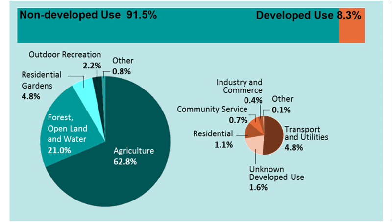
If An average CO2 emission from a vehicle is 12.6kg/day, and a full-grown tree absorbs 30kg/year of environment CO2 ( 0.08 kg/day). Then 150 full-grown trees are capable of clearing out this CO2. So with the amount of undeveloped land we have do we have the problem of planting trees? Is there a real problem with CO2 emission?
The development plans subject of the study lacked any concentration on protecting wildlife and natural habitat.
International research and studies show that urban development projects constructed in the previous years were not successful. The amount of derelict urban space they created is huge, the number of landscape areas could be used for another function that was not considered, the proportion of development to open and green space was not in balance, and urban corridors between buildings used by pedestrians were not studied properly and it is used for functions damaging the communities surrounding it. Specialists in the field of urban planning and from an architecture base expect local development plans to consider these design defects and to study the target city based on the ideas presented here.
Mobility area study in previous local plans defined the five factors affecting the development of mobility policies and strategies. These five factors are each type of transport capacity, people’s behavior in using transport, the performance of the city transport system, scope for change in the different types of transport, the environmental effect of these transport types. The plans defined what type of problems exist in each type of transport such as reliability, comfort, and congestion in use. The subsequent plans such as the local development plan 2016 changed the way the study is conducted and did not present what are the cities transport problems. Mainly every local plan depends on the previous plan and builds on it. The modern local development plans focus on connecting the available transport networks components with cycling and walkability.
Now, what makes specific authorities develop a mobility plan within the local development plan?
The city population is one of the factors that affect the transportation network. The increase or population shift from other cities are the main influencers to change the mobility plan. Cities are built and developed through the years and accordingly the transport network. The development within a certain area of the city reaches a limit where horizontal expansion becomes more costly and complex. The more complex the expansion is the more time is required to develop the transport network because of required FUNDS. Funds could come from different sources:
- Income tax
- Sales tax
- Tolls
- Bonds
- State, local, and federal excise taxes
- State infrastructure banks
- Credit assistance sources
Adding to this major factor affecting the development process three other factors should be considered. Land use, development densities, and transport system carrying capacity. These factors affect each other concurrently. When a city reaches the maximum carrying density capacity there is no point in developing road networks as you can not keep on increasing the size of roads and highways. For public transport, every bus has a carrying capacity and reaching time requirements depending on roads clearance and congestion as increasing the number of buses reach a limit that could not be expanded. The time interval between each bus arrival in the station reaches its limits that there will be no buses to accommodate in the plan. Similarly, the train and underground transport system also reach a capacity that could not be developed. For example, in X area there is an increase in development and population density that require more trains to carry this population in peak hours. There will be no rational point in adding a train station in the area because it will not affect the maximum number of trains that a line could carry and the time intervals between each train reaching a station. Adding another train to absorb the increase in the population served will not solve the problem for the same previous reason. The three factors (land use, development densities, and transport system capacity) must be considered always. For further information, you can read my article about these factors click here.
Be First to Comment