Transport planning vs transport modelling is an article that defines the two fields. It shows the series of activities involved in the two fields. Who use these two fields, and in which projects or location. The article aims to identify the use of the two fields in practice related to an urban design project. The article does not intend to describe or criticize the two fields in government work or private sector agencies.
Transport planning vs transport modelling: definitions
Transport planning: Is the field that steady and assesses ways to provide excess to land and underpins current and future economic patterns of growth and activities. It’s the process of developing strategies for operating, managing, maintaining, and financing the area’s transport system in a way to advances the area’s long-term goals.
Transport modelling: Is the field that studies and provides evidence-based (computer simulation) of the current transport system and infrastructure and includes the impact of future change. It deals with collecting and analysis of current statistics of human choice and behavior of and how to travel. Also, improvements of the specific Mode of transport and its impact on others.
Public sector agencies or private sector agencies working for the government do transport planning in most countries in the world. The Complex process needs high-level expertise and knowledge to do the activities. They include monitoring existing conditions. Forecasting future population and major growth areas. Identifying current and future transport problems, needs, and strategies to address these needs and problems.
In addition, developing short and long-term capital improvements for moving goods and people. Also, defining the impact of recommended improvements to the transport system on the environment. Finally, developing a financial plan for securing funds to cover the costs of implementing strategies. See Figure 1, the transport planning process in the USA context.

In the same manner, these agencies do transport modelling. The process includes a four-stage model hierarchy. Most modelling models include these four stages, like the gravity model. Trip generation includes estimating the number of trips from one zone to another. Mode split is to estimate how the trips generated in the first stage divide between transport modes. Trip distribution is to ensure every trip is tied To a destination at a reasonable distance.
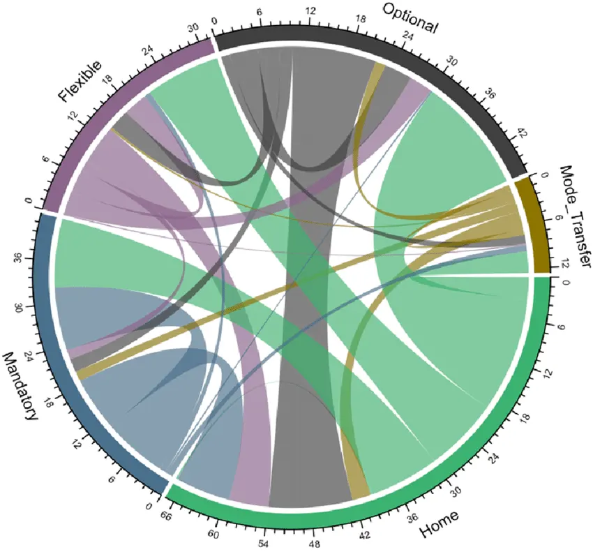
The trip assignment represents the last stage of the calculation. Here, we estimate the number of trips to every network. We get to know the total Amount of volume of traffic to each network. Therefore, to study and analyze the crowding of the public network. Figure 2, the chord diagram shows the model matrix of trips between zones and each one.
Transport planning vs transport modelling: in practice
In many areas in the world, transport planning represents the spine of development. It’s the core of the planning process and a major element for decision-making for urban development. Let’s take an example from practice, the interchange 1 in the Emirate of Dubai. This node continued to provide the high traffic flow to three major high-density developments. In recent years, after 2006 traffic capacity of roads and bridges has become very large.
The Roads and Transport Authority, a government agency, started a process of initial efforts to develop this node. In conjunction with an International transport company , a study was made, and a plan was developed. Construction companies carried out the work, and the node roads and bridges became very complex. What made it simpler for drivers to digest while driving was the signage. Nevertheless, still, the node is one of the biggest frustrations for drivers and planning failures.
One of the biggest challenges is to develop an area transport road network with unplanned or unassessed properly work. The adjacent areas developed by the planning authority were just to attract international investment without detailed planning. Absence of effective mass transit, unpredictable car ownership, and its massively increased numbers made a Hazel for drivers in the serving zones of this node. See my video of the node near Burg Khalifa after development in 2025.
Transport planning represents a major success of the Western world in using it within physical planning. The USA context and some other EU countries’ continuous success highlight successful lessons for other countries.
Transport planning vs transport modelling: two types of models in practice
As I have shown in the previous paragraph, physical planning success gives lessons on the two fields use in practice. Transport modelling is one of the core activities in the transport planning process to lay out a plan. The evidence-based scenarios of solutions for a traffic problem provide decision makers the ability to judge alternatives. Whether that developing a highway, or transit station or building new roads, or a bus station.
Within physical planning (still operating in most developed countries except the UK), modelling depends on available stored data of people and their travel behavior. Specialists in the field suffer because it’s hard to predict travel behavior, because some trips (in the same zone) are not counted. Nevertheless, several factors make modelling easier and more accurate.
In physical planning, planners identify land uses, the area development densities, and related criteria. Also, types of buildings automatically recorded. In this manner, a station size and carrying capacity are designed to fulfill the physical plan, land use, densities, and building types. Therefore, road network will become easy to design and to predict its sizes and the traffic volume it carries.
Accordingly, modelling here becomes a tool, a model to check the traffic volume that every zone creates during development. Also, it’s compatibility with the existing system. If the development creates higher traffic than the physical plan estimated, then planners provide solutions. Surely, this includes increasing bus lines, increasing trains’ carrying capacity by increasing the number of trains, or decreasing the time between station stops. Surely, that leads to reduced car usage.
Within non-physical planning, a model used by planners and urban designers is called the piece-by-piece model. I have worked in my previous career in different countries in the world, and in the Gulf region, but did not witness its use. The UK planning system and urban designers use this model in practice, just to show pioneering, innovation, and supremacy in planning. As I will show, this does not exist in practice, full of failures.
An urban development starts within the piece-by-piece model when demand appears. Here in this specific area, planners have not predicted land use, or predicted densities, or types of buildings. Road network will be designed based on the demand of the development itself. Planners will carry out modelling on data, likely to be very complex to predict, for the reason I mentioned.
Building mass transit for that more likely to be a very complex decision because of high cost and approval process from the government and funders. Also, the required number of people to exist to make the station construction feasible. Planners will face difficulty in designing the road network because of the absence of accurate data on the new development. This model shows the UK planning illness because it’s tailored to decrease public funds, not to serve developers or the development quality.
This model (piece by piece) would reduce government funds to build the stations. Road network and related infrastructure cost less because only the required for the development will be realized. The government will tackle this problem of planning by creating bus lines or increasing the number of buses to pass the development. I have written several articles on the defects of the UK local plan building. I have provided an alternative approach in published articles. You can read the articles (1), (2), (3), (4) for more details.
Be First to Comment