City in layers-part 5- An urban design concept is the fifth article of a series1,2,3,4. In fact, this article aims to analyze London’s urban design between 1945-1970. Specifically, to discuss urban renewal of the inner London. Furthermore, the effect of the CIAM code of urban planning on the renewal and London urban design. Also, the chaos and arbitrary urban planning of London councils and planners. Despite the officials’ and planners’ experience, they have failed to find an effective resolution for London.
City between (1945-1970), the inner regeneration and the CIAM code.
Surely, city of London, after World War 2, faced a challenge of reconstruction of the destruction made in the center and the docks by the German bombing. Therefore, the city councils took this opportunity to lay out a development plan to reconstruct it and resolving the major previous defect issues. The concentration of most city’s population in the inner urban fabric was one major issue that needed resolution. In addition, the concentration of major heavy industry and chemical manufacturing in inner city. Environmental problems such as Pollution caused by industries relying on coal for generating power. Moreover, an absence of proper green space for outdoor activity. Bad and chaos in city building and code regulations. Finally, the inefficient transport system and road network.
The urban planning professionals in the city councils and related nonprofit organizations suggested several concepts to resolve these problems. To begin with, the translation of an official urban plan was in the late 1950s in an official London development plan. Furthermore, the urban regeneration plan laid out by a professor in architecture and urban planner comprised three major mini plans to achieve.
The mini-Plans
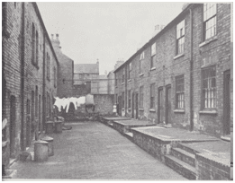
First, shifting population in satellite towns within the city boundaries in order to start regeneration of the inner city (Figure 1). Second, developing the road network and a city ring road and arteries to the center, as well as building extra underground and train lines within the city. Third, shifting the industries causing pollution in the inner city to the boundaries and adjacent cities, as well as building green space network within the city.
The post-war plan was to rebuild, reshape, and renewal of the urban fabric and the informing context for that was the modernization and the ideas of the CIAM. Certainly, the ideas that were codified in the 1947 advisory handbook for developing the central areas of the city. The councils applied major concepts of city central regeneration of London in the period of 1945-1970.Firstly, the emphasis on extensive planning, concentrating on daylight and floor space indicators. Also, vehicle circulation concentrates on free-flow road systems. Moreover, linking parking provisions and segregation of functions through zoning. Achieving that by particular concentration on zoning out residential uses. Separating retail and office uses and finally confining institutions to the campus.
The inner urban renewal comprises also major decentralization of trades, commercial zones linked to railway stations. Also, shift of highway locations to urban peripheries. Surely, this illustrates that the metropolis contains different approaches, concepts, methodologies. These were under the research of urban development in the timeline 1945-1970. Not only the underground system was under development. Specifically, majority of spatial structures were under regeneration, part of that is the London docks, which were mainly damaged by German bombing. City in layers-part 5- An urban design concept showed here the actions and plans of related authorities.
City in layers-part 5- An urban design concept, chaos in Urban planning.
The city grew from a couple of villages around water stream. Major work locations build near rivers to use it for transferring goods to other cities to reduce cost of production. Other industries used water in the production and operation such as electricity and chemical plants. After the industrial revolution, and the machine invention arbitrary and unplanned development was carried out. Road networks were built following the existing routes regardless of whether they were in correct position or sufficient to carry the flow of goods and people.
This gives the interested party in rebuilding cities to consider various issues related to the major urban planning plan. The plan should be built on collaborative efforts from several disciplines as architecture, planning, environment, engineering, infrastructure, economics, and political governance. Looking into the city as a combination of layers based on their activities, roads, train lines, green system, people’s movement routes, cultural buildings and historical buildings, sports arenas, water beds and surfaces, living areas and buildings , and commercial zones. See my previous article –City in layers part 4– for detail info.
Final note, in building the plan it is essential to focus on which of these layers should be considered first in the development and a hierarchy of other layers and their interaction on each other. You can read my book review the urban design process to grab the full idea of the city in layers.
Following, I inserted a list of references that supplied the research. In addition, a reference list for further reading.
- Trancik,Roger.(1986) Finding lost space .New York-USA : Van Nostrand Reinhold
- Cuthbert, R.Alexander. (2011) Understanding Cities method in urban design. Oxon-UK ,Routledge (Taylor & Francis group).
- Shane, David Grahame. (2011) Urban design since 1945. West Sussex-London: Wiley & Sons Ltd.
- Lynch, Kevin. (1960) Image of the city .London-UK: MIT Press.
- Tallon, Andrew. (2013)Urban regeneration in the UK. Second edition.Oxon-Uk: Routledge (Taylor & Francis group).
- Lang, Robert. (2003) Edgeless Cities are exploring the elusive metropolis. Washington-USA: Brookings Institution’s press.
- Wallinger, Mark. (2014)Labyrinth a journey through London’s underground .London-Uk: Arts book Publishing.
- Carmona et al .(2003)Public places , urban spaces – the dimensions of urban design .Oxford-Uk : architectural press.
- Laurie, Micheal. (2002)Introduction to landscape architecture. New jersey –USA: PTR prentice hall.
- Czerniak, Julia&Hargreaves, Jeorge. (2007)Large Parks. New York-USA: Princeton Architectural Press.
- Turner, Tom. (1998)Landscape Planning and environmental impact design.London-Uk: UCL Press.
- Osborn, F.J. (1946) Garden cities of tomorrow. London-UK: Faber&Faber.
- Cherry, Gordon E. (1972) Urban change and planning – a history of urban development in Britain since 1750.Oxfordshire-UK: GT Foulis & CO LTD.
- Liversedge, Jamie&Holden, Robert. (2014)Landscape architecture an introduction. London-UK: Laurence King LTD.
- OC, Taner&Tiesdell, Steven.(1997)Safer city centers reviving the public realm . Liverpool-UK: Paul Champon Publishing.
- Evans, Alun Sylvester. (1980) urban renaissance a better life in towns.England-UK: Robert stockwell LTD.
- Longley,Paul&Batty,Michael.(1994)Fractal Cities a geometry of form and function .London-Uk: Academic Press
- Greeves, Ivan .S. (1980) London Docks 1800-1980 a civil engineering history. London-UK: Thomas Telford Limited.
- Trench, Richard.Hillman, Eliss. (1985)London under London a subterranean guide.London-Uk: John Murray LTD.
[…] in layers-part 6- An urban design concept is the sixth article of a series1,2,3,4,5. In fact, this article aims to analyze London’s urban design between 2000-2015. Specifically, […]
[…] in layers: urban design in professional practice is the seventh article of a series1,2,3,4,5,6. Defining and analyzing the new urban design concept. In this article, I will summarize the […]