Urban structure theories
Geographers examined various forms or blueprints of urban structure & growth; there studies focused on two countries in the world, UK cities and one of the biggest cites in USA the city of Chicago. Cuthbert inquiry of the urban theory revealed that Chicago school of sociology was the most significant in developing different types of typologies of urban structure in the twentieth century propagated in the concentric theory, the sector theory and the multiple–nuclei theory of Harris and Ulman.Figure1 illustrates the how the urban structure theories create different urban forms or blueprint.
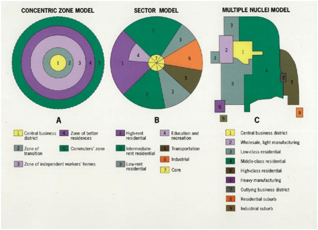
Burgess concentric Zones theory is rings of functional areas starting from the center the high density of business district, ring of light industry and low-quality resident, ring of independent Non-family workers, ring of better homes for families, ring of commuters.
Hoyt sector theory is developed from the first theory the sectors are centered around the CBD in the middle, composed of six sectors starting from high rent residential, intermediate residential, low rent residential, educational and recreation, transportation, and industries.
Harris and Ulman nuclei theory is nuclei areas around a centric zone ; the CBD is the core zone surrounded by wholesale and light manufacture , low-class residential areas , middle-class residential areas and the other area connected to the center through other zones such as high-class residential , heavy manufacture , residential suburban and industrial suburban .
Major failure of urban structure theories
These theories were an outcome of socioeconomic studies of industrial cities in the world specifically Chicago city and major UK cities like Sunderland. Their research spotted the immigrants to USA living in industrial cities in bad living conditions and targeted specific behavior, including alcoholism, homicide, suicides, psychoses, and poverty, and then computing rates based on census data.
These theories presented a blueprint of land use in cities that were criticized later of segregation and social isolation, leading to derelict areas, abundant places, and city deprivation. The theories introduced several important factors in urban planning and urban design for consideration: design and living conditions, efficiency of infrastructure, tackling environmental issues, transit network availability and affordability.
But, laying out a blueprint of an area or a city without considering urban design principals and best practices is a major catch on these theories. Transport planners are in isolation when these theories where introduced as many factors in urban transit affect urban design and vise-versa. Part1,2 connects the discussion and gives a wholistic view of the city in layers concept for more details click here.
References:
- Trancik,Roger.(1986) Finding lost space .New York-USA : Van Nostrand Reinhold
- Cuthbert, R.Alexander. (2011) Understanding Cities method in urban design. Oxon-UK ,Routledge (Taylor & Francis group).
- Shane, David Grahame. (2011) Urban design since 1945. West Sussex-London: Wiley & Sons Ltd.
- Lynch, Kevin. (1960) Image of the city .London-UK: MIT Press.
- Tallon, Andrew. (2013)Urban regeneration in the UK. Second edition.Oxon-Uk: Routledge (Taylor & Francis group).
- Lang, Robert. (2003) Edgeless Cities are exploring the elusive metropolis. Washington-USA: Brookings Institution’s press.
- Wallinger, Mark. (2014)Labyrinth a journey through London’s underground .London-Uk: Arts book Publishing.
- Carmona et al .(2003)Public places , urban spaces – the dimensions of urban design .Oxford-Uk : architectural press.
- Laurie, Micheal. (2002)Introduction to landscape architecture. New jersey –USA: PTR prentice hall.
- Czerniak, Julia&Hargreaves, Jeorge. (2007)Large Parks. New York-USA: Princeton Architectural Press.
- Turner, Tom. (1998)Landscape Planning and environmental impact design.London-Uk: UCL Press.
- Osborn, F.J. (1946) Garden cities of tomorrow. London-UK: Faber&Faber.
- Cherry, Gordon E. (1972) Urban change and planning – a history of urban development in Britain since 1750.Oxfordshire-UK: GT Foulis & CO LTD.
- Liversedge, Jamie&Holden, Robert. (2014)Landscape architecture an introduction. London-UK: Laurence King LTD.
- OC, Taner&Tiesdell, Steven.(1997)Safer city centers reviving the public realm . Liverpool-UK: Paul Champon Publishing.
- Evans, Alun Sylvester. (1980) urban renaissance a better life in towns.England-UK: Robert stockwell LTD.
- Longley,Paul&Batty,Michael.(1994)Fractal Cities a geometry of form and function .London-Uk: Academic Press
- Greeves, Ivan .S. (1980) London Docks 1800-1980 a civil engineering history. London-UK: Thomas Telford Limited.
- Trench, Richard.Hillman, Eliss. (1985)London under London a subterranean guide.London-Uk: John Murray LTD.
[…] raised “How do cities grow and change within the developed world?” The book develops the urban growth models to present this metropolitan planning […]
[…] conducting land use modeling and the distribution of the land uses depends on the location and the distance to the CBD. Land use Value determines what type of land is used in a certain location in a development and […]
[…] City dwellers and visitors in this timeline, were using water transport system as one of the affordable means of transport. Planners in Public and private sector planned the city several docks which were under construction and London docks were planned and approved by council for construction. Pearson a City professional tried to advocate the idea of using the drains for subway as construction lines for the proposed underground. Because of the failures to control the on-ground transport system and heavy traffic in the inner city. Pearson, one of the city planners, envisaged the long-distance subway to run beneath the roads under archways. As shown in (figure 1) connecting several urban public space nodes in the city such as Paddington, Euston, St Pancreas, kings cross, to Farringdon accessing central London. And this is how can transit network affect the city urban form. […]
[…] two theories the production of space and the image of the city. The writer discusses the failure of Kevin launch theory as it neglects the meaning of the created spaces and the stories behind it; he presents five […]
[…] the third article School of Chicago sociology theories based on economic development define the city and its urban […]