City in layers-part 4- An urban design concept is the fourth article of a series1,2,3. In fact, this article aims to analyze London’s urban design between 1900-1935. Specifically, to discuss transport development proposals. Furthermore, the city survey of major industries. Also, inner city problems and authorities’ reactions. In addition, I present my discussion of the failures of these proposals. Surely, as per my experience in transport planning and modelling, I have highlighted moreover what is required to solve these problems. Despite the officials’ and planners’ experience, they have failed to find an effective resolution for London.
City in layers-part 4- An urban design concept, Transport development proposals
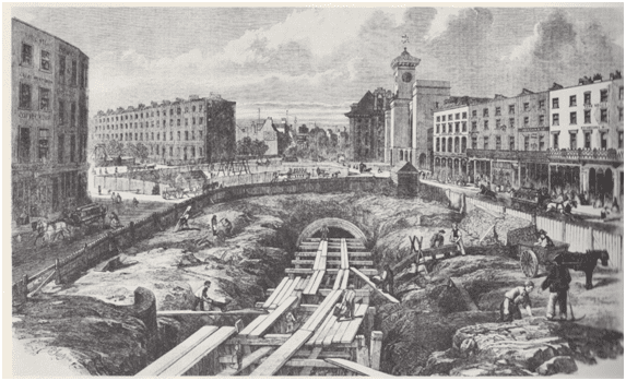
City dwellers and visitors in this timeline were using water transport system as one of the affordable means of transport. Indeed, planners in Public and private sectors planned the city several docks, which were under construction. Additionally, London Docks were planned and approved by the council for construction. Pearson, a city professional, in certain circumstances, tried to advocate the idea of using the drains for a subway as construction lines for the proposed underground. That’s because of the failures to control the on-ground transport system and heavy traffic in the inner city. Pearson, also one of the city planners, envisaged the long-distance subway to run beneath the roads under archways. As shown in Figure 1, connecting several urban public space nodes in the city, such as Paddington, Euston, St Pancras, King’s Cross, to Farringdon, accessing central London. And this is how can transit network can affect the city’s urban form.
City survey of major industries
In conducting a detailed survey about the industries in this period, the result was major industries were heavy industries. Steel factories, chemicals, glass, mills, and wood industry related requiring heavy transport means. In reality, the major transport means were water, and most of these industries were located near rivers. Minor industry individuals located their plants near the city center because they do not require heavy transport. Understanding the city layers highlights the major problem of the unplanned allocation of major industries, as well as related labor required for the factories. Therefore, the city professionals and planners were trying to create major changes to the city Layers. Apparently, by building an underground system to facilitate people’s and workers’ movement to various areas in the city. They did not think, obviously, from seeing the London plan of 1935, to connect water transport to the underground.
City in layers-part 4 An urban design concept, Inner city problems
The inner part of the city was facing environmental and health problems due to many socio-economic and even political problems. Indeed, one of the major problems that dominated the scene in the city center is the low wages and the extreme use of women in factories. Moreover, many families were forced to live in lodgings in a room of 12 persons with singles, where many girls were abused and subject to rape. Certainly, the increase in densities in homes and uncontrolled construction and quality created health problems, where there were limited responses from the government. Besides, every area in a council had one registered doctor, and sometimes it was a veterinarian.
Authority’s reactions
These destructive problems turned the concern of the architects and local agencies to establish new governance for the new construction and new concepts. The Boundary Street scheme, the company town such as Port Sunlight, and the Letchworth town plan idea, which were identically planned and constructed to improve the industrial life. In conclusion, for this period, the reform of the City from slums, unhealthy and environmentally unfriendly, to planned towns, designed infrastructure, and developed transport systems. Surely, spatial structure was rebuilt on the studied themes and schemes. The huge and major change in planning and design of the city layers is proof that these layers work interactively, but not standalone. Therefore, planners and urban designers’ comprehensive knowledge in many fields is mandatory.
What is required to connect city layers properly.
Major knowledge in transport planning and modeling is a prerequisite. Economic planning to control fiscal matters of locating major industries in the city. Political planning to control the governing rules of construction and labor work rights. Environmental planning to consider major issues affecting any city development reform. Landscape architecture to allocate the required healthy and physical outdoor areas for public use and protecting wildlife. The architecture of a building to achieve a comfortable human living and contribute to wellbeing and quality of life indicators. Finally, the major player in this scenario represents the urban designer that mange-monitor- implements–all the previous work to achieve the planned goals.
Following, I inserted a list of references that supplied the research. In addition, a reference list for further reading.
- Trancik,Roger.(1986) Finding lost space .New York-USA : Van Nostrand Reinhold
- Cuthbert, R.Alexander. (2011) Understanding Cities method in urban design. Oxon-UK ,Routledge (Taylor & Francis group).
- Shane, David Grahame. (2011) Urban design since 1945. West Sussex-London: Wiley & Sons Ltd.
- Lynch, Kevin. (1960) Image of the city .London-UK: MIT Press.
- Tallon, Andrew. (2013)Urban regeneration in the UK. Second edition.Oxon-Uk: Routledge (Taylor & Francis group).
- Lang, Robert. (2003) Edgeless Cities are exploring the elusive metropolis. Washington-USA: Brookings Institution’s press.
- Wallinger, Mark. (2014)Labyrinth a journey through London’s underground .London-Uk: Arts book Publishing.
- Carmona et al .(2003)Public places , urban spaces – the dimensions of urban design .Oxford-Uk : architectural press.
- Laurie, Micheal. (2002)Introduction to landscape architecture. New jersey –USA: PTR prentice hall.
- Czerniak, Julia&Hargreaves, Jeorge. (2007)Large Parks. New York-USA: Princeton Architectural Press.
- Turner, Tom. (1998)Landscape Planning and environmental impact design.London-Uk: UCL Press.
- Osborn, F.J. (1946) Garden cities of tomorrow. London-UK: Faber&Faber.
- Cherry, Gordon E. (1972) Urban change and planning – a history of urban development in Britain since 1750.Oxfordshire-UK: GT Foulis & CO LTD.
- Liversedge, Jamie&Holden, Robert. (2014)Landscape architecture an introduction. London-UK: Laurence King LTD.
- OC, Taner&Tiesdell, Steven.(1997)Safer city centers reviving the public realm . Liverpool-UK: Paul Champon Publishing.
- Evans, Alun Sylvester. (1980) urban renaissance a better life in towns.England-UK: Robert stockwell LTD.
- Longley,Paul&Batty,Michael.(1994)Fractal Cities a geometry of form and function .London-Uk: Academic Press
- Greeves, Ivan .S. (1980) London Docks 1800-1980 a civil engineering history. London-UK: Thomas Telford Limited.
- Trench, Richard.Hillman, Eliss. (1985)London under London a subterranean guide.London-Uk: John Murray LTD.
[…] and surfaces, living areas and buildings , and commercial zones. See my previous article –City in layers part 4– for detail […]
[…] that make the system easy to construct. Voids in the city that were a good location to connect all transport systems lines became development […]
[…] fourth article shows the government intervention to respond to many city problems when starting a development plan […]